
Google Map’s live view is now available to anyone passing through Sydney Airport — neat!
Google has today announced the availability of Live View in Sydney Airport.
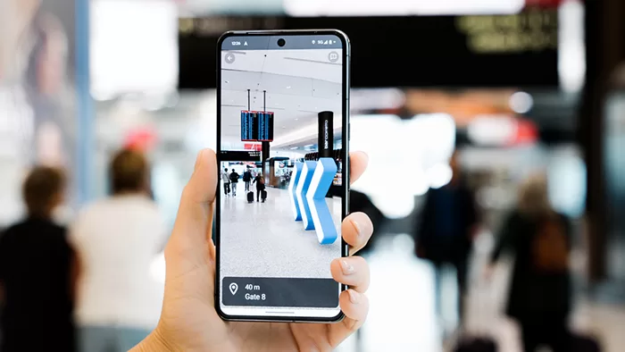
If you’re not familiar, Live View is an AR-assisted companion to Google Maps that lets you overlay directional arrows and other indicators to help you get to where you’re going.
It’s been a part of Google Maps for years now, and quite handy to help with orientation on maps, because it scans your location using the camera to give you a position, then tells you precisely where it is you need to go — within reason.
And now it’s available for passengers going through Sydney Airport, with a directory of available services and a setting specifically for wheelchair accessible routes if that’s a feature you need.
Live View is available via Google Maps, which is preinstalled on pretty much every Android phone, or available for iPhones via the Apple App Store. You don’t have to install any other apps to get it working; once you’ve got a route in place through Maps, tilting up the phone to vertical will engage Live View to help you find where it is you’re meant to go.
Alex’s Take
Look, I’ll be honest here, I’ve never found Sydney Airport that hard to get around relative to other airports… but then this very much isn’t for me, but more for international tourists and domestic ones not familiar with the layout, or folks running late for a flight, or those who need to find where the chemist is… and so on.
I have had some experiences going through Sydney Airport with annoying pushy types barging past with luggage, and I can’t imagine that those same folks will be any less pleasant if they’ve got their eyes glued to their phones. Then again, many of them already did, and that’s a human problem, not a technology one.
Live View is really neat technology, built on machine learning around millions of photographs already taken, though it does bring with it the slightly big-brother-esque realisation that this has been done with publicly available photos en masse.
While I haven’t used it (and doubt I’d need to) in Sydney Airport, I have used it when travelling overseas if only to ensure that I’m walking in the right direction, because sometimes the GPS lock on where you are isn’t always 100%, especially if you’re coming out of a building or similar.
Google Maps still isn’t perfect — as a good example, trying to find Kaiyodo HobbyLand in Osaka it sent me to the bins at the back of the building — but it’s certainly improved a lot over the years.